Getting There
Take turn onto the Sawbill Trail off Highway 61 in the town of Tofte. Continue until it ends. The Sawbill Trail basically ends in the parking lot of Sawbill Canoe Outfitters and the Sawbill Campground.
Outfitter and Pre-Trip Lodging Info
Sawbill Canoe Outfitters has been family owned and operated since 1957. Third-generation owners Clare and Dan Shirley are keeping the family-tradition of helping people enjoy the wilderness. Sawbill is a full service outfitter. They can help you will all of you gear, some of your gear, or just a canoe rental. They do not have an cabin rentals, but the Sawbill Campground is just 100 yards away and a great place to sleep the day before and after your BWCA Trip.
2 to 3 Day One-Lake, No Portage Loop | Sawbill Lake Only | Blue Route on Map
- For those wanting to experience the BWCA without doing any portages.
- Put your boat in at the boat launch near the Sawbill Campground.
- Explore and stay on Sawbill Lake.
- Campsites: 13
- Size: 834 acres with a max depth of 45 feet.
- Paddling a loop around the lake will be a distance of about 2.5 miles.
2 to 4 Day Extremely-Short-Portage Loop: Sawbill to Kelso to Alton | Orange Route on Map
- Cover a greater distance with only three short portages and explore two large lakes and one small lake.
- Put in your boat at the boat launch near the Sawbill Campground.
- Paddle a short way up Sawbill Lake to Kelso River.
- Take the 18.5-rod portage between Sawbill Lake and Kelso River
- Take the Kelso River into Kelso Lake.
- Explore and Stay on Kelso Lake.
- Campsites: 3
- Size: 133 acres with a max depth of 16 feet.
- Paddle down to the southern end of Kelso Lake (do not go back into Kelso River)
- Take the 12.8-rod portage between Kelso Lake and Alton Lake.
- Campsites: 16
- Size: 969 acres with a max depth of 72 feet.
- Midway down Alton Lake, you will find the 28.5-rod portage back to Sawbill Lake.
- Paddling this loop will cover roughly 12 miles of paddling total if you paddle the whole length of Alton and only paddle on Sawbill until Kelso River.
3 to 4 Day Short-Portage Route: Sawbill to Smoke to Burnt to Flame | Green Route on Map
- Cover a greater distance with only three short portages and explore three smaller lakes.
- Put in your boat at the boat launch near the Sawbill Campground.
- Paddle about halfway up Sawbill Lake to the Smoke Lake Portage.
- Take the 107-rod portage between Sawbill Lake and Smoke Lake.
- Explore Smoke Lake
- Campsites: 4
- Size: 158 acres with a max depth of 20 feet.
- Things to Do: Go fishing or explore the small inlet on the north end of the lake.
- Paddle straight across Smoke to the Burnt Lake Portage.
- Take the 95-rod portage between Smoke Lake and Burnt Lake.
- Explore Burnt Lake
- Campsites: 6
- Size: 358 acres with a max depth of 23 feet.
- From the Smoke Lake to Burnt Lake portage go north to the Flame Lake portage.
- Take the 59-rod portage between Burnt Lake and Flame Lake.
- Explore Flame Lake.
- Campsites: 1
- Size: 51 acres with a max depth of 22 feet.
- This is not a loop route. You will need to head back to Sawbill via the Flame Lake, Burnt Lake, and Smoke Lake portages.
- Paddling this route will cover roughly 12 miles of paddling total if you do a loop around all three lakes and only paddle on Sawbill until the Smoke Lake portage.
4 to 6 Day Sawbill Adventure | Sawbill to Alton to Kelso to Sawbill to Smoke to Burnt to Flame | Combine Orange and Green Routes on Map
- Combine the three routes above for a longer trip covering a greater area and six great lakes.
- Refer to the routes above. The only adjustment we’d make would be to enter into Sawbill Lake and immediately take the portage into Alton Lake. Then take the portage into Kelso Lake and back down the Kelso River to Sawbill Lake. Essentially reversing the Sawbill – Kelso – Alton loop. Going back into Sawbill Lake from Kelso River puts you closer to the Smoke Lake portage.
- This route gives you many more campsite opportunities. If you are heading out on a busy weekend, you can look for an available campsite mid-Sawbill Lake and use that as your basecamp, doing the Kelso – Alton loop one day and the Smoke – Burnt – Flame route another while keeping your basecamp on Sawbill.
- Depending on how much you explore, you could paddle 25+ miles over the course of your trip.
Map
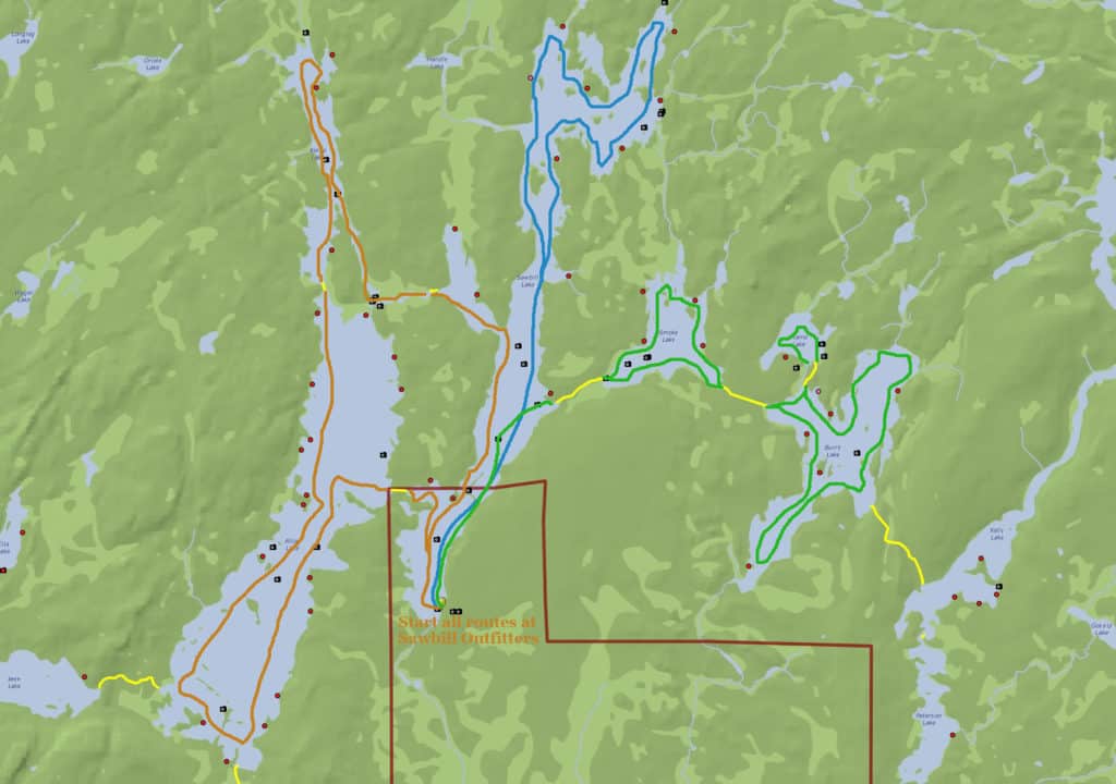
Click here to view full-sized image
Getting There
Head up the Gunflint Trail from Grand Marais for about 27 miles and turn right on E Bearskin Rd. After 0.7 miles on E Bearskin Road turn right onto Forest Rd. 60.
Outfitter and Pre-Trip Lodging Info
Bearskin Wilderness Outfitters offer complete or partial outfitting for canoe trips anywhere along the Gunflint Trail and eastern BWCA area. The outfitters is located within the Bearskin Lodge and Resort, which offers a variety of lodging options you can enjoy before and after your BWCA trip. East Bearskin Lake Campground is also nearby.
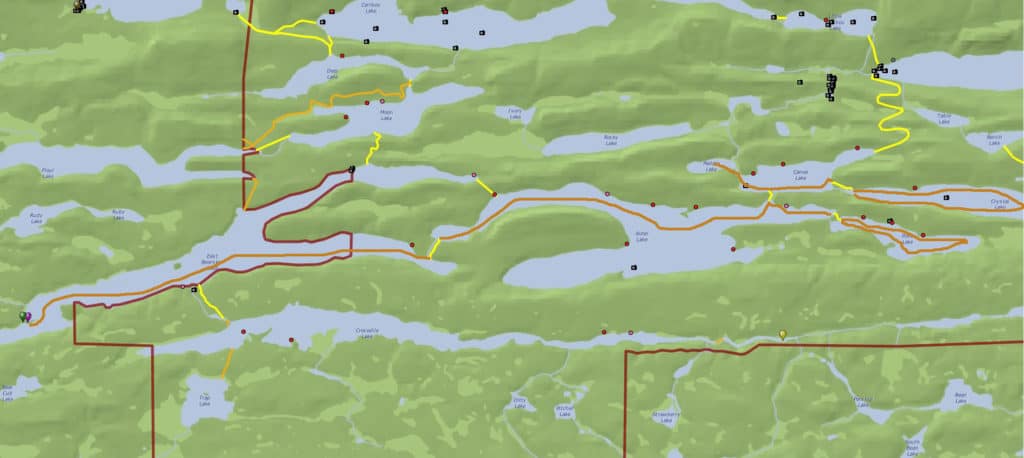
2 Day Extremely-Short-Portage Loop: East Bearskin to Alder | Dark Orange Route
- For those with limited time to explore, this loop is quick and easy with the two 50-rod portages.
- Launch into East Bearskin Lake and go to the southwestern Alder Lake portage.
- Take the 52-rod portage between East Bearskin Lake and Alder Lake.
- Explore Alder Lake.
- Campsites: 7
- Size: 528 acres with a max depth of 72 feet.
- Head to the northwest inlet of Alder Lake to the take the second 52-rod portage back to East Bearskin Lake.
- If you only paddle from East Bearskin Lake to Alder Lake, and do not portage to any smaller lakes, you will paddle roughly 12 miles total.
Make this route a longer trip by taking the extremely short portages into smaller, nearby lakes like Pierz Lake, Canoe Lake, Paddle Lake, and Crystal Lake. If you cannot find a campsite on Alder there are some on Pierz Lake and Canoe Lake.
There are also several day-trip options such as East Bearskin Lake to Flour Lake to Aspen Lake. The Aspen Lake to East Bearskin Lake portage actually brings you right to Bearskin Lodge and Resort. There are no campgrounds on these lakes and they are not in the BWCA, so they are a day-trip only.
Map
Getting There
Duncan Lake is accessible through Bearskin Lake. We recommend Hungry Jack Outfitters on Hungry Jack Lake to access Duncan Lake. Take the Gunflint Trail to the mid-trail area. Take a right onto Hungry Jack Road and then stay to the right of the fork to go onto S Hungry Jack Road. Stay on S Hungry Jack Road until the road ends at Hungry Jack Canoe Outfitters. This will take you to Hungry Jack Outfitters where you can portage to EP 60 at Duncan Lake.
You can get closer to the EP by taking the left of the fork to stay on Hungry Jack Road. About 0.7 miles down the road you will see a public parking area on the left side of the road. This will give you access to West Bearskin Lake which is a short trip across the lake to EP 60 at Duncan Lake.
Outfitter and Pre-Trip
Hungry Jack Outfitters is a family-owned and operated currently operated by Dave and Nancy Seaton. Dave and Nancy, and their staff, are a wealth of knowledge about the BWCA. They are a full service outfitter and also have two cozy cabins for rent that you can stay in before and/or after your BWCA trip. Or basecamp from a cabin and day trip into the BWCA.
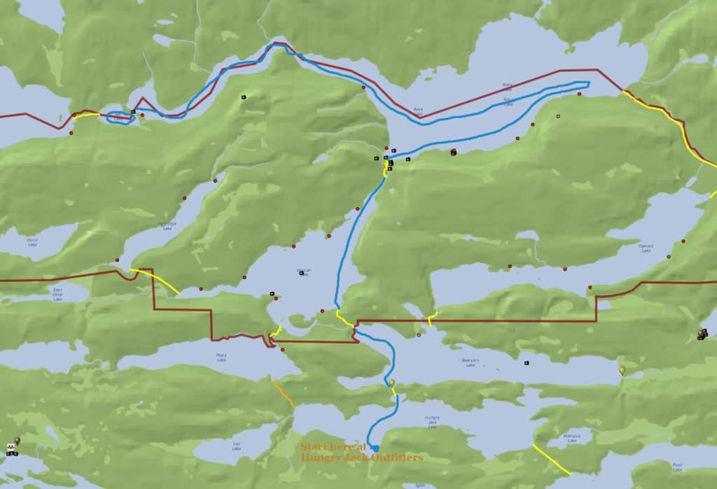
2 to 4 Day Short Portage Route: Duncan to Rose (Optional: Rat Lake)
- Experience the stairway portage and a beautiful waterfall on this popular route.
- Depart from Hungry Jack Outfitters on Hungry Jack Lake.
- Paddle the short way across Hungry Jack Lake.
- Take the 20-rod portage to Bearksin Lake.
- Paddle to short way across Bearskin Lake.
- Take the 81-rod portage to Duncan Lake.
- Explore Duncan Lake:
- Campsites: 7
- Size: 472 acres with a max depth of 130 feet.
- Paddle the long way across Duncan Lake.
- Take the 77-rod portage to Rose Lake. Note: this is the stairway portage.
- Explore Rose Lake (this is a border lake that is half in the US and half in Canada. A passport is needed for traveling on the Canadian side.):
- Campsites: 8 (all on the US side)
- Size: 628 acres with a max depth of 90 feet.
- Optional: Paddle to the far west side of Rose Lake.
- Take the extremely short 8-rod portage to Rat Lake.
- Explore Rat Lake:
- Campsites: 0
- Size: 15.9 acres with a max depth of 5 feet.
- This is not a loop route. You will need to head back to Rose, Duncan, Bearskin, and Hungry Jack Lakes via the portages to return to the outfitters.
- Paddling this route will cover roughly 18 miles of paddling total if you explore all of Duncan Lake, Rose Lake on the US side, and Rat Lake.
Map
Getting There
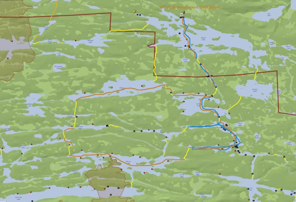
Like Duncan Lake, Lizz Lake is easier to access via another lake that is not in the BWCA: Poplar Lake. We recommend using Rockwood Lodge & Outfitters on Poplar Lake for EP 47 trips. To get to Rockwood Take the Gunflint Trail to the mid-trail area. Turn left onto Rockwood Road.
Outfitter and Pre-Trip Lodging Info
Rockwood Canoe Outfitters is another family-owned and operated, full-service outfitter. Rockwood is owned by two brothers and their wives who purchased Rockwood in 2015 after having worked at Rockwood several years prior. In addition to providing outfitting services, Rockwood also offers 8 cabins and a bunkhouse for lodging. You can stay at Rockwood before and after your BWCA adventure, or use Rockwood as a basecamp if you don’t want to camp in the BWCA.
2 to 4 Day Short Portage Route: Lizz to Caribou to Horseshoe | Blue Route on Map
- This simple introduction to the southern mid-trail area is great for those just starting out.
- Put in your boat Rockwood Outfitters (alternatively, there is a public launch on Poplar Lake that you can use).
- Paddle across Poplar Lake to EP 47.
- Take the 46-rod portage to Lizz Lake.
- Paddle across Lizz Lake.
- Take the 68-rod portage to Caribou Lake.
- Explore Caribou Lake:
- Campsites: 8
- Size: 270.5 acres with a max depth of 26 feet.
- Paddle to the southeast corner of Caribou Lake and take the 22-rod portage to Horseshoe Lake.
- Explore Horseshoe Lake:
- Campsites: 7
- Size: 210 acres with a max depth of 26 feet.
- This is not a loop route. You will need to double back to Caribou and Lizz Lake to return to Poplar Lake.
- Paddling this route, if you explore all of Caribou and Horseshoe Lakes will cover roughly 12 miles total.
5 to 7 Day Loop: Lizz to Caribou to Horseshoe to Gaskin to Henson to Pillsbery to Swallow to Meeds (loop back to Caribou) | Orange Route on Map
- This route has one longer portage (105 rods).
- Start by following the route above (Lizz to Caribou to Horseshoe).
- Paddle to the southwest corner of Horseshoe Lake.
- Take the 98-rod portage to Gaskin Lake.
- Paddle across Gaskin the far west side.
- Explore Gaskin Lake:
- Campsites: 10
- Size: 427 acres with a max depth of 82 feet
- Take the 91-rod portage to Henson Lake.
- Explore Henson Lake:
- Campsites: 5
- Size: 139 acres with a max depth of 40 feet
- Paddle the short way across Henson Lake.
- Take the 51-rod portage to Pillsbery Lake.
- Explore Pillsbery Lake:
- Campsites: 2
- Size: 75.5 acres with the max depth unknown.
- Paddle across Pillsbery to the north-central side.
- Take the 89-rod portage to Swallow Lake.
- Explore Swallow Lake:
- Campsites: 0
- Size: 37 acres with a max depth unknown
- Paddle the short way across Swallow Lake.
- Take the 105-rod portage to Meeds Lake.
- Explore Meeds Lake:
- Campsites: 3
- Size: 370 acres with a max depth of 41 feet
- Paddle the long way across Meeds Lake to the eastern side.
- Take 26-rod portage to the into a creek and the 13-rod portage out of the creek to Caribou Lake.
- Paddle across Caribou Lake to the northeast corner to get back to the Lizz Lake Portage.
- This “epic” trip covers 9 lakes and a small creek. You will need to take 11 shorter portages and one longer portage, so only take this route if you enjoy portaging a lot. Be sure to give yourself plenty of time to travel. 5 days is the minimum a beginner will likely be able to do this route, and that’s if you do not take time to explore and just do the route. A week would be best. You will cover about 16 miles on this journey total round trip.
Map
Getting There
Even though the EP 51 is called Missing Link Lake, you actually enter into Round Lake. From the Gunflint Trail turn left onto Round Lake Road. Continue on Round Lake Road for less than a mile. Round Lake Road dead-ends at Tuscarora Lodge & Canoe Outfitters.
Outfitter and Pre-Trip Lodging Info
Tuscarora Lodge & Canoe Outfitters is owned by Andy McDonnell and Ada Igoe. Both were born and raised in the Grand Marais area and know the BWCA well. Tuscarora is a full-service outfitter, including having several cabins and lodge rooms for before and after your stay. In addition to being a great outfitter for overnight BWCA trips, Tuscarora would also make a great basecamp for those wanting to just take day trips.
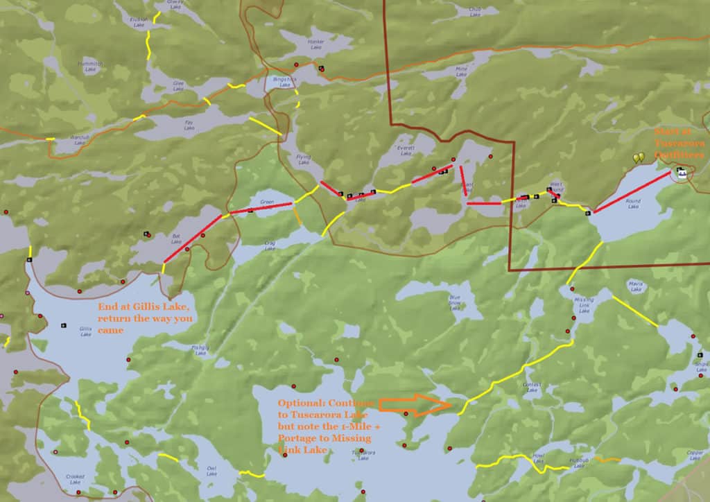
3 to 4 Day Small Lake Route: Round Lake to Gillis Lake | Red Route on Map
- This route has many portages which can be very challenging. Some portages like to flood in the spring. Others include steep inclines. You will also have only 6 campsites you will come across until you reach Gillis Lake! It’s a great route if you want more of a challenge for your first trip.
- Enter Round Lake at EP 51 Missing Link Lake.
- Paddle across Round Lake to the West Round Lake Portage.
- Take the 77-rod portage to West Round Lake.
- Paddle across West Round Lake.
- Take the 46-rod portage to Edith Lake.
- Paddle across Edith Lake.
- Take the 33-rod portage to Brandt Lake (at this point you are in the BWCA).
- Explore Brandt Lake:
- Campsites: 3 (all along the north side and the only campsites on this route!)
- Size: 115 Acres with a max depth of 80 feet
- Paddle to the northwest corner of Brandt Lake and take the 88-rod portage to Gotter Lake.
- Paddle to the northwest corner of Gotter Lake and take the 13-rod portage to Flying Lake.
- Paddle about 1/4 of the way up Flying Lake and you will see the portage to Green Lake on the left-hand side of the lake.
- Take the 73-rod portage to Green Lake.
- Paddle straight across Green Lake to the far side.
- Take the 18-rod portage to Bat Lake.
- Explore Bat Lake:
- Campsites: 3
- Size: 83 acres with a max depth of 110 feet.
- Paddle to the southeast corner of Bat Lake and take the 21-rod portage to Gillis Lake.
- Gillis Lake is the largest lake you will encounter on this trip! Explore Gillis Lake
- Campsites: 7
- Size: 616 acres with a max depth of 180 feet.\
- This is not a loop route. You will need to double back the way you came. (There is a loop if you go from Gillis to Crooked Lake to Owl Lake to Tuscarora to Missing Link Lake back to Round Lake. However, the portage between Tuscarora and Missing Link Lake is over a mile long and very challenging. We do not recommend for your first trip.)
- Paddling this route, if you explore all of Gillis Lake, is about 13.5 miles.
2 to 3 Day Small Lake Route: Stop at Brandt Lake
- Follow the above route, but stop at Brandt Lake. If you can find on of the 3 campsites open, snag it up and use this lake as a basecamp to explore the small lakes nearby. The portages will be less difficult if you do not have all your gear. We put this route second as getting a campsite on Brandt may be difficult. Do not plan to take this route but rather adjust your plans if you can do it.
Map